St. Libory, NE
Description
Courtesy of Jim Hebbeln
Latitude 41:06:20 N; Longitude 98:27:22 W.
Good picture available from Google Earth.
St. Libory was an auxiliary (relay) station on AT&T's first transcontinental microwave radio route, linking Fullerton to the east and Gibbon to the west.
Like all of the stations on that route, St. Libory was originally equipped with KS-5759 delay-lens antennas, which were replaced with KS-15676 horn-reflectors.
Also, like most towers on the Omaha-Denver segment, the "cabin in the sky" radio room was located about 75 feet below the tower platform to reduce waveguide signal loss.
The steel joists and roof rafters can be seen about midway up the tower.
When the delay-lens antennas were replaced with horn-reflector antennas, the radio equipment was moved to a building on the ground.
The station is now owned by Industrial Communications who has reused the original antennas and added more.
The site is located about one and one-half miles north and five miles west of St. Libory, or four miles west of US Highway 281, on Highway 58.
Images
Courtesy of Jim Hebbeln
Select an image to view a larger version.

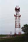
Look east on Highway 58 at the west side of the St. Libory tower - and Mumpumpey Hill. |
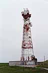
This is a view of the south side of the St. Libory tower. |
A view of the southwest side of St. Libory. |
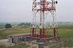
By standing on top of Mumpumpey Hill, I was able to get a nice picture of the east elevation of the lower tower showing the St. Libory building, and surrounding area in the drizzle. |
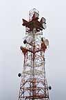
This view is from the same location on Mumpumpey Hill but shows the upper part of the tower, including a particularly good view of the white I-beam joists which once supported the "cabin in the sky" radio room. |
 |
Return to...
Updated on February 18, 2006 at 21:31 by Albert LaFrance