Images
Photos courtesy of Larry TigheSelect an image to view a larger version

Common Language Location Identifier (CLLI): LYPTPAQ0010
Geolocation (GL) code: PA7300
Address: On an access road branching northeast off Rt. 309 about 5.1 roadway miles northwest of New Tripoli, Lehigh County, PA.
Latitude: N40-42-55 (40.71527)
Longitude: W75-47-55 (-75.79860)
Elevation: 1552 ft. (473 M)
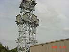
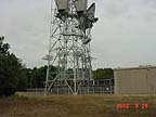
Lynnport's physical facilities consist of a 138 ft. (42M) self-supporting steel tower and a reinforced concrete building. The tower supports multiple pairs of Western Electric KS-15676 horn-reflector antennas.
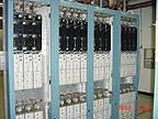
Lynnport was a microwave radio junction station.
The March 1998 FCC microwave license database shows Lynnport having microwave links to Freeland and Topton Mountain, PA. Long Lines route maps from January 1970 and from 1979 show Lynnport with links going north to Freeland, south to Geigertown, east to Allentown No. 2 and southwest to Centerport, PA. The station does not appear on an October 1966 map.
As AT&T converted its network from to fiber optics, Lynnport became obsolete and was shut down. AT&T sold the facility to American Tower Corporation, which leases space on the tower to cellular-telephone companies and other wireless telecommunications clients. American Tower has created an online Site Brochure describing the facility.
Thanks to Terry Michaels for contributing the CLLI and GL code data.
|
|
|
|
Created on June 9, 2003 at 22:23 by Albert LaFrance