Images
Select image to view a larger version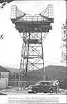
From the AT&T booklet "The Telephone in America", August 1955
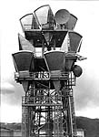
Image courtesy of Jim Hebbeln, from 1975
Buckhorn Mountain was a station on AT&T's first transcontinental microwave route. It linked Crow Creek Hill, Wyoming and Broomfield, Colorado.
By 1969, the delay lens antennas at Buckhorn Mountain, CO, had been replaced with cornucopia horn antennas, and a new pair of antennas (facing the camera in the 1975 photo below) were installed and aimed to a new Timnath, CO, site (actually about eight miles east of Fort Collins and 3/4 mile north of Colorado Highway 14.) At Timnath, the radio route turned abruptly 90 degrees south and was aimed at the Longmont, CO, site where the radio intersected with a hardened L4 coax route. The coax was a leg between Denver, CO, and an underground site, Platte Junction, WY, on the east-west transcontinental route .
The Longmont site is actually located atop a broad hill of wheatfields on the east side of I-25 near the town of Mead. (Some locals have tongue-in-cheek called this 100' high hill "Mount Mead". Contrary to popular local belief, an SUV is not required to negotiate Mount Mead in a snow storm.)The round parabolic dish on the top level carried only "E2A" alarm and telemetry signals from the equipment in the building down to the Longmont site. Buckhorn Mountain then became an unmanned site.
The view east of the "the fruited plain" from 8300' elevation Buckhorn Mountain is spectacular! Indeed, each of the other relay sites interconnected with Buckhorn Mountain (Broomfield, Greeley, Timnath, and Cheyenne) are located on the flat lands east of the Colorado Front Range of mountains, except for Crow Creek Hill near Laramie, WY. On clearer days, one can see the other towers with a good pair of binoculars.
From the AT&T booklet "The Telephone in America", August 1955 |
Image courtesy of Jim Hebbeln, from 1975 |
Updated on May 26, 2003 at 22:20 by Albert LaFrance